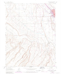
1962 Map of Montrose West
USGS Topo · Published 1984About this map
The Uncompahgre River corridor dominates this 1960s landscape, illustrating the critical intersection of natural hydrology and man-made irrigation in Western Colorado. The town of Montrose serves as the focal point, with the Denver and Rio Grande Western tracks threading through its industrial and residential core. Beyond the town limits, the reliance on diverted water is evident through the complex network of the Montrose and Delta Canal, West Canal, and the BNB Lateral, which transformed the surrounding mesas into productive land.
Find a feature on this map
39 named features on this map. Tap any name to fly to it.
Don’t see what you’re looking for? This feature index may not catch every label — zoom into the map to look around manually.
Map Details
Editions of this 1962 Montrose West Map
4 editions found
Other maps of this area

1909 · Montrose
USGS Topo · 1:125,000

1911 · Montrose
USGS Topo · 1:125,000

1955 · Olathe
USGS Topo · 1:24,000

1955 · Red Rock Canyon
USGS Topo · 1:24,000

1956 · Montrose
USGS Topo · 1:250,000

1956 · Moab
USGS Topo · 1:250,000

1959 · Moab
USGS Topo · 1:250,000

1959 · Montrose
USGS Topo · 1:250,000

1960 · Montrose
USGS Topo · 1:250,000

1960 · Moab
USGS Topo · 1:250,000