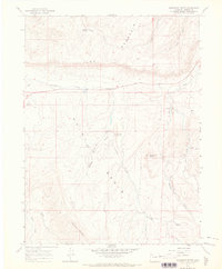
1966 Map of Monument Butte
USGS Topo · Published 1969About this map
The high plateau and drainage basins of Moffat County are defined here by the Iles Dome Oil Field, a landscape marked by scattered oil wells and pumping stations. Near the center of the sheet, the former settlement of Loyd is noted as a site, while early watering points like Ralston Springs and the sheltered Iles Grove provided essential stops in this arid terrain. The map's topography is dominated by the massive ridge of Iles Mountain and the distinct peak of Monument Butte, which overlooks a complex network of seasonal drainages including Stinking Gulch and Seeping Spring Gulch. To the south, Thornburg Mountain rises above the Milk Creek valley, where a series of jeep trails and gravel pits suggest a landscape driven by resource extraction and ranching at the time of the 1966 field check.
Find a feature on this map
27 named features on this map. Tap any name to fly to it.
Don’t see what you’re looking for? This feature index may not catch every label — zoom into the map to look around manually.
Map Details
Editions of this 1966 Monument Butte Map
3 editions found
Other maps of this area

1910 · Danforth Hills
USGS Topo · 1:125,000

1912 · Meeker
USGS Topo · 1:62,500

1912 · Axial
USGS Topo · 1:62,500

1914 · Meeker
USGS Topo · 1:62,500

1914 · Axial
USGS Topo · 1:62,500

1915 · Monument Butte
USGS Topo · 1:62,500

1954 · Craig
USGS Topo · 1:250,000

1957 · Craig
USGS Topo · 1:250,000

1958 · Craig
USGS Topo · 1:250,000

1960 · Craig
USGS Topo · 1:250,000