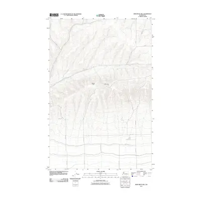
2011 Map of Monument Hill
USGS Topo · Published 2011About this map
Beezley Hills dominate the topography of this Grant County landscape, showing the dramatic elevation changes and geological formations characteristic of the region. The ridge is punctuated by Mounment Hill, while the lower elevations are defined by a strictly organized grid of local transit routes such as Adams Rd N and Martin Rd NW. The contrast between the steep, unpopulated terrain of the hills and the precisely surveyed sections of the surrounding flats reflects the region's agricultural and land-use history. Significant thoroughfares like Baird Springs Rd and Overen Rd cut through the northern half of the quadrangle, providing access across the rising ground. This 2011 survey illustrates the intersection of natural basaltic landforms and the systematic human imposition of the Public Land Survey System.
Find a feature on this map
19 named features on this map. Tap any name to fly to it.
Don’t see what you’re looking for? This feature index may not catch every label — zoom into the map to look around manually.
Map Details
Editions of this 2011 Monument Hill Map
This is the sole edition of this map. No revisions or reprints were ever made.
Other maps of this area

1909 · Quincy
USGS Topo · 1:62,500

1910 · Quincy
USGS Topo · 1:62,500

1910 · Winchester
USGS Topo · 1:62,500

1953 · Ritzville
USGS Topo · 1:250,000

1956 · Ephrata
USGS Topo · 1:62,500

1956 · Ephrata SW
USGS Topo · 1:24,000

1959 · Ritzville
USGS Topo · 1:250,000

1965 · Ritzville
USGS Topo · 1:250,000
1966 · Winchester
USGS Topo · 1:24,000
1966 · Monument Hill
USGS Topo · 1:24,000