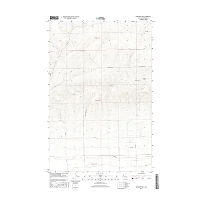
2017 Map of Monument Hill
USGS Topo · Published 2017About this map
Monument Hill and the Beezley Hills dominate this section of the Columbia Basin in central Washington. The landscape is defined by a rigorous grid of section lines and gravel roads that serve the high plateau, illustrating the intersection of the Public Land Survey System with modern rural infrastructure. Major thoroughfares such as Baird Springs Rd NW and Monument Hill Rd NW traverse the rolling terrain, which is largely divided into agricultural or rangeland sections within Townships t21n r24e and t22n r24e. The southern reaches of the map show a transition toward more frequent east-west travel routes like Martin Rd NW and Rd 13 NW. This 2017 survey provides a precise accounting of contemporary land use and elevation in a region shaped by both its volcanic geology and organized land division.
Find a feature on this map
20 named features on this map. Tap any name to fly to it.
Don’t see what you’re looking for? This feature index may not catch every label — zoom into the map to look around manually.
Map Details
Editions of this 2017 Monument Hill Map
This is the sole edition of this map. No revisions or reprints were ever made.
Other maps of this area

1909 · Quincy
USGS Topo · 1:62,500

1910 · Quincy
USGS Topo · 1:62,500

1910 · Winchester
USGS Topo · 1:62,500

1953 · Ritzville
USGS Topo · 1:250,000

1956 · Ephrata
USGS Topo · 1:62,500

1956 · Ephrata SW
USGS Topo · 1:24,000

1959 · Ritzville
USGS Topo · 1:250,000

1965 · Ritzville
USGS Topo · 1:250,000
1966 · Winchester
USGS Topo · 1:24,000
1966 · Monument Hill
USGS Topo · 1:24,000