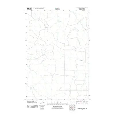
2011 Map of Moon Creek School
USGS Topo · Published 2011About this map
Snell Creek and West Fork Cottonwood Creek define the drainage patterns of this rural landscape in southeastern Montana. The area is characterized by a network of intermittent streams and coulees that feed into larger water bodies like Cottonwood Creek and Moon Creek. Human modification of the landscape is evident in infrastructure such as the McLean Number 1 Dam, which manages water resources in an otherwise arid environment. Travel through the territory is largely centered on Moon Creek Rd, which serves as a primary north-south artery. The presence of features such as Graveyard Creek and Hay Creek suggests a landscape shaped by both natural erosion and the practical needs of local ranching or agricultural operations during the early 21st century.
Find a feature on this map
8 named features on this map. Tap any name to fly to it.
Don’t see what you’re looking for? This feature index may not catch every label — zoom into the map to look around manually.
Map Details
Editions of this 2011 Moon Creek School Map
This is the sole edition of this map. No revisions or reprints were ever made.
Other maps of this area

1953 · Miles City
USGS Topo · 1:250,000

1954 · Forsyth
USGS Topo · 1:250,000

1957 · Miles City
USGS Topo · 1:250,000

1957 · Forsyth
USGS Topo · 1:250,000

1958 · Miles City
USGS Topo · 1:250,000

1958 · Forsyth
USGS Topo · 1:250,000

1968 · Hathaway
USGS Topo · 1:24,000

1968 · Lignite Creek
USGS Topo · 1:24,000

1968 · Horton
USGS Topo · 1:24,000
1969 · Jack Creek NW
USGS Topo · 1:24,000