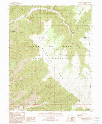
1991 Map of Moonwater Point
USGS Topo · Published 1991About this map
The Uintah and Ouray Indian Reservation covers the heart of this landscape, where the plateaus of the East High Plateaus meet the Tavaputs Plateau. This 1991 provisional survey documents a highly dissected terrain defined by steep drainage systems and narrow ridges. Central to the topography is Moonwater Point, a massive landform surrounded by the intricate erosional patterns of Moonwater Canyon and Deep Canyon. The map reveals a vital network of isolated water sources essential to this arid environment, including Anna Laura Spring, Pinto Springs, and Maros Water.
Find a feature on this map
20 named features on this map. Tap any name to fly to it.
Don’t see what you’re looking for? This feature index may not catch every label — zoom into the map to look around manually.
Map Details
Editions of this 1991 Moonwater Point Map
This is the sole edition of this map. No revisions or reprints were ever made.
Other maps of this area

1885 · East Tavaputs
USGS Topo · 1:250,000

1886 · Price River
USGS Topo · 1:250,000

1896 · Price River
USGS Topo · 1:250,000

1953 · Firewater Canyon
USGS Topo · 1:62,500

1954 · Flat Canyon
USGS Topo · 1:62,500

1954 · Range Creek
USGS Topo · 1:62,500

1956 · Price
USGS Topo · 1:250,000

1956 · Grand Junction
USGS Topo · 1:250,000

1959 · Grand Junction
USGS Topo · 1:250,000

1960 · Price
USGS Topo · 1:250,000