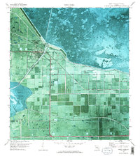
1970 Map of Moore Haven
USGS Topo · Published 1976About this map
Moore Haven serves as the focal point of this orthophotomosaic, situated where the Caloosahatchee Canal exits the southwestern shore of Lake Okeechobee. The landscape is defined by extensive water management engineering, including the massive Herbert Hoover Dyke and the Old Moore Haven Canal. Settlement patterns are concentrated along these waterways and the Seaboard Coast Line railroad, featuring local neighborhoods like Washington Park and institutional landmarks such as St Josephs Ch and the Booker T Washington Sch.
Find a feature on this map
24 named features on this map. Tap any name to fly to it.
Don’t see what you’re looking for? This feature index may not catch every label — zoom into the map to look around manually.
Map Details
Editions of this 1970 Moore Haven Map
2 editions found
Other maps of this area

1956 · West Palm Beach
USGS Topo · 1:250,000

1957 · West Palm Beach
USGS Topo · 1:250,000

1958 · West Palm Beach
USGS Topo · 1:250,000

1970 · Moore Haven
USGS Topo · 1:24,000

1970 · Clewiston South
USGS Topo · 1:24,000
1970 · Lakeport
USGS Topo · 1:24,000

1970 · La Belle 4 NW
USGS Topo · 1:24,000

1970 · La Belle 4 NE
USGS Topo · 1:24,000
1971 · Fisheating Bay
USGS Topo · 1:24,000
1971 · Clewiston North
USGS Topo · 1:24,000