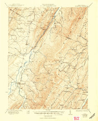
1922 Map of Moorefield
USGS Topo · Published 1950About this map
Moorefield serves as the focal point of this Hardy County survey, situated where the South Branch Potomac River meets the valley floor between the high ridges of Mill Creek Mountain and Elkhorn Mtn. The landscape is defined by the rigid North-South orientation of the Appalachian ridges, which dictated the path of the Baltimore and Ohio RR as it followed the river's course. Rural life in the 1920s is evidenced by an exceptionally dense network of one-room schoolhouses, including the Powder Lick School and Phils Lick School, alongside remote mountain outposts like Glebe PO and Fabius.
Find a feature on this map
106 named features on this map. Tap any name to fly to it.
Don’t see what you’re looking for? This feature index may not catch every label — zoom into the map to look around manually.
Map Details
Editions of this 1922 Moorefield Map
2 editions found

Other maps of this area

1891 · Romney
USGS Topo · 1:125,000

1892 · Franklin
USGS Topo · 1:125,000

1892 · Woodstock
USGS Topo · 1:125,000

1895 · Piedmont
USGS Topo · 1:125,000

1896 · Franklin
USGS Topo · 1:125,000

1919 · Elk Garden
USGS Topo · 1:48,000

1920 · Elk Garden
USGS Topo · 1:48,000

1920 · Petersburg
USGS Topo · 1:48,000

1920 · Moorefield
USGS Topo · 1:62,500

1920 · Keyser
USGS Topo · 1:62,500