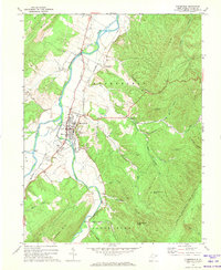
1970 Map of Moorefield
USGS Topo · Published 1974About this map
Moorefield serves as the focal point of this Hardy County survey, situated at the confluence of the South Branch Potomac River and the South Fork. The town's industrial and community infrastructure is well-defined, featuring a Tannery, Filtration Plant, and a High Sch on its southern edge. The Baltimore and Ohio railroad corridor tracks alongside the river, passing through the smaller settlement of Taylor and past a local Drive-in Theater.
Find a feature on this map
45 named features on this map. Tap any name to fly to it.
Don’t see what you’re looking for? This feature index may not catch every label — zoom into the map to look around manually.
Map Details
Editions of this 1970 Moorefield Map
2 editions found
Other maps of this area

1891 · Romney
USGS Topo · 1:125,000

1892 · Franklin
USGS Topo · 1:125,000

1892 · Woodstock
USGS Topo · 1:125,000

1895 · Piedmont
USGS Topo · 1:125,000

1896 · Franklin
USGS Topo · 1:125,000

1920 · Petersburg
USGS Topo · 1:48,000

1920 · Moorefield
USGS Topo · 1:62,500

1921 · Orkney Springs
USGS Topo · 1:48,000

1921 · Petersburg
USGS Topo · 1:48,000

1921 · Greenland Gap
USGS Topo · 1:62,500