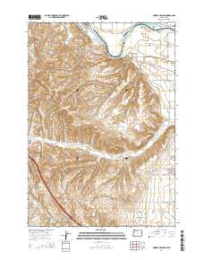
2014 Map of Moores Hollow
USGS Topo · Published 2014About this map
The Snake River carves a critical boundary through this landscape, separating Malheur County, Oregon from Washington County, Idaho. This riverine environment is defined by its agricultural infrastructure, where the Owyhee Canal, Slide Ditch, and Upper Ditch draw water into the surrounding basins. Significant alluvial features like Westlake Island and McRea Island sit within the river's path, while the adjacent Weiser Flat and Lower Dead Ox Flat indicate a long history of floodplain utilization. The small settlements of Annex and Moores Hollow are connected by a network of local roads such as Olds Ferry-Ontario Hwy and Moores Hollow Rd. The terrain is further marked by numerous gulches, including Shepherd Gulch and Coyote Gulch, which channel seasonal runoff toward the river. Local landmarks like Wheel Gulch Basin Spring and Wickiup Springs provide vital water points in an otherwise arid drainage system.
Find a feature on this map
38 named features on this map. Tap any name to fly to it.
Don’t see what you’re looking for? This feature index may not catch every label — zoom into the map to look around manually.
Map Details
Editions of this 2014 Moores Hollow Map
This is the sole edition of this map. No revisions or reprints were ever made.
Other maps of this area

1897 · Weiser
USGS Topo · 1:125,000

1951 · Moores Hollow
USGS Topo · 1:24,000

1951 · Malheur Butte
USGS Topo · 1:24,000

1951 · Moores Hollow
USGS Topo · 1:62,500

1951 · Payette
USGS Topo · 1:24,000

1951 · Weiser South
USGS Topo · 1:24,000

1952 · Olds Ferry
USGS Topo · 1:24,000

1952 · Olds Ferry
USGS Topo · 1:62,500

1952 · Olds Ferry SE
USGS Topo · 1:24,000

1953 · Mann Creek
USGS Topo · 1:62,500