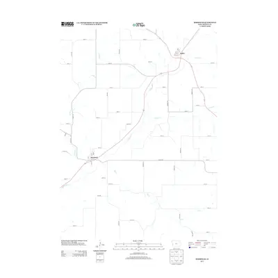
2013 Map of Moorhead
USGS Topo · Published 2013About this map
Moorhead and Soldier anchor this section of western Iowa, where the Soldier River carves a diagonal path across the agricultural landscape. The township's layout is defined by a rigid section-line grid of rural roads, including Pecan Ave and Poplar Ave, which intersect with the wandering courses of several local waterways. The topography is shaped by the drainage patterns of Jordan Cr and Norway Cr, which feed into the primary river valley. Within the small village footprints, a concentrated street grid appears with named thoroughfares like Ash St, Oak St, and Elm St. This survey reflects the enduring spatial organization of Monona County's farming communities, where the proximity to water sources like Elk Cr and Skinners Cr originally influenced the placement of these crossroads settlements.
Find a feature on this map
39 named features on this map. Tap any name to fly to it.
Don’t see what you’re looking for? This feature index may not catch every label — zoom into the map to look around manually.
Map Details
Editions of this 2013 Moorhead Map
This is the sole edition of this map. No revisions or reprints were ever made.
Other maps of this area

1954 · Omaha
USGS Topo · 1:250,000

1954 · Fort Dodge
USGS Topo · 1:250,000

1957 · Omaha
USGS Topo · 1:250,000

1957 · Fort Dodge
USGS Topo · 1:250,000

1958 · Omaha
USGS Topo · 1:250,000

1958 · Fort Dodge
USGS Topo · 1:250,000

1969 · Castana
USGS Topo · 1:24,000
1971 · Mapleton SE
USGS Topo · 1:24,000

1971 · Moorhead SE
USGS Topo · 1:24,000

1971 · Ute
USGS Topo · 1:24,000