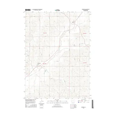
2015 Map of Moorhead
USGS Topo · Published 2015About this map
The Soldier River valley carves through the Western Iowa loess hills, anchoring the rural communities of Moorhead and Soldier. This 2015 survey illustrates a landscape deeply defined by its drainage network, where local life follows the contours of Norway Cr, Skinners Cr, and Elk Cr. The mapping of townships t83n r43w and t82n r43w reveals a rectilinear grid of secondary roads like Co Hwy L20 and Co Hwy E54 that navigate the challenging topography. For genealogists and local historians, the inclusion of the Spring Valley Cem near Moorhead and the Soldier Cem to the north provides specific points of interest for tracing family heritage in Monona County. Distinctive features like Bartlett Hills Lake contrast with the surrounding agricultural uplands, marking this as a characteristically Midwestern riverine landscape.
Find a feature on this map
36 named features on this map. Tap any name to fly to it.
Don’t see what you’re looking for? This feature index may not catch every label — zoom into the map to look around manually.
Map Details
Editions of this 2015 Moorhead Map
This is the sole edition of this map. No revisions or reprints were ever made.
Other maps of this area

1954 · Omaha
USGS Topo · 1:250,000

1954 · Fort Dodge
USGS Topo · 1:250,000

1957 · Omaha
USGS Topo · 1:250,000

1957 · Fort Dodge
USGS Topo · 1:250,000

1958 · Omaha
USGS Topo · 1:250,000

1958 · Fort Dodge
USGS Topo · 1:250,000

1969 · Castana
USGS Topo · 1:24,000
1971 · Mapleton SE
USGS Topo · 1:24,000

1971 · Moorhead SE
USGS Topo · 1:24,000

1971 · Ute
USGS Topo · 1:24,000