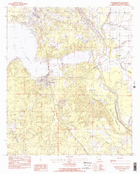
1982 Map of Mooringsport
USGS Topo · Published 1982About this map
The waters of Caddo Lake and the complex drainage of the Red River basin dominate this northwestern Louisiana landscape. In the early 1980s, the area's development was concentrated around Mooringsport and Oil City, reflecting the region's long-standing connection to the petroleum industry on Pine Island. The intricate network of waterways, including Black Bayou, Twelvemile Bayou, and Shiftail Canal, illustrates the engineered efforts to manage the low-lying terrain near the Soda Lake State Wildlife Management Area.
Find a feature on this map
27 named features on this map. Tap any name to fly to it.
Don’t see what you’re looking for? This feature index may not catch every label — zoom into the map to look around manually.
Map Details
Editions of this 1982 Mooringsport Map
2 editions found
Other maps of this area

1932 · Shreveport SE
USGS Topo · 1:31,680

1932 · Hosston SW
USGS Topo · 1:31,680

1932 · Hosston SE
USGS Topo · 1:31,680

1932 · Shreveport NE
USGS Topo · 1:31,680

1944 · Kildare
USGS Topo · 1:62,500

1944 · Caddo Lake
USGS Topo · 1:62,500

1946 · Caddo Lake
USGS Topo · 1:62,500

1948 · Kildare
USGS Topo · 1:62,500

1948 · Mooringsport
USGS Topo · 1:62,500

1948 · Vivian
USGS Topo · 1:62,500