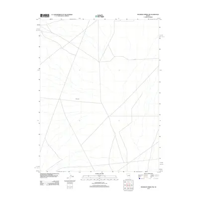
2012 Map of Moorman Spring NW
USGS Topo · Published 2012About this map
The Cove defines this stretch of the Great Basin in eastern Nevada, characterized by an expansive network of intermittent drainages and natural washes. The terrain reflects the arid landscape of Nye County, where water movement is seasonal and shapes the local topography through complex alluvial patterns. This 2012 survey by the U.S. Geological Survey documents the sparse infrastructure of the region, anchored primarily by Co Rd-14. The road network provides the essential transit corridor through this open country, illustrating the scale of rural land management and the persistent reliance on established gravel or dirt routes to navigate the high desert floor between mountain ranges.
Find a feature on this map
2 named features on this map. Tap any name to fly to it.
Don’t see what you’re looking for? This feature index may not catch every label — zoom into the map to look around manually.
Map Details
Editions of this 2012 Moorman Spring NW Map
This is the sole edition of this map. No revisions or reprints were ever made.
Other maps of this area

1956 · Lund
USGS Topo · 1:250,000

1957 · Currant Mtn
USGS Topo · 1:62,500

1960 · Lund
USGS Topo · 1:250,000

1964 · Currant
USGS Topo · 1:62,500

1964 · Currant Mtn
USGS Topo · 1:62,500

1969 · Moorman Spring SE
USGS Topo · 1:24,000

1969 · Moorman Spring NW
USGS Topo · 1:24,000

1969 · Moorman Spring
USGS Topo · 1:24,000

1969 · Moorman Spring NE
USGS Topo · 1:24,000
1978 · Lund
USGS Topo · 1:24,000