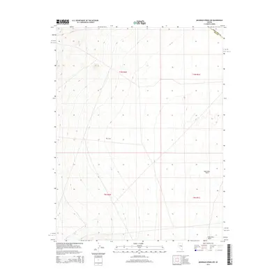
2014 Map of Moorman Spring NW
USGS Topo · Published 2014About this map
White River Valley dominates this 2014 survey of the high desert basin along the border of White Pine and Nye counties. The landscape is defined by the broad, low-lying expanse of the valley floor, which sits between prominent mountain ranges just beyond the margins of this sheet. A localized geological depression known as The Cove sits in the central portion of the quadrangle, illustrating the complex drainage patterns and alluvial formations characteristic of the Great Basin region. This modern topographic study focuses on the vast open reaches of the basin-and-range interior, where surveying lines for townships like t10n r60e and t9n r61e provide the primary framework for understanding the geography of this sparsely populated corner of Nevada.
Find a feature on this map
7 named features on this map. Tap any name to fly to it.
Don’t see what you’re looking for? This feature index may not catch every label — zoom into the map to look around manually.
Map Details
Editions of this 2014 Moorman Spring NW Map
This is the sole edition of this map. No revisions or reprints were ever made.
Other maps of this area

1956 · Lund
USGS Topo · 1:250,000

1957 · Currant Mtn
USGS Topo · 1:62,500

1960 · Lund
USGS Topo · 1:250,000

1964 · Currant
USGS Topo · 1:62,500

1964 · Currant Mtn
USGS Topo · 1:62,500

1969 · Moorman Spring SE
USGS Topo · 1:24,000

1969 · Moorman Spring NW
USGS Topo · 1:24,000

1969 · Moorman Spring
USGS Topo · 1:24,000

1969 · Moorman Spring NE
USGS Topo · 1:24,000
1978 · Lund
USGS Topo · 1:24,000