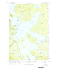
1957 Map of Moosehead Lake
USGS Topo · Published 1984About this map
Mt Kineo rises prominently over the western shore of the lake, serving as a central landmark for this 1957 survey of the Maine woods. The landscape is defined by large island masses like Sugar Island and Deer Island, and the complex shoreline of Spencer Bay. Cultural development is concentrated along the western edge near Rockwood and the southern reaches near Moosehead, where the Canadian Pacific railroad cuts through the forest.
Find a feature on this map
140 named features on this map. Tap any name to fly to it.
Don’t see what you’re looking for? This feature index may not catch every label — zoom into the map to look around manually.
Map Details
Editions of this 1957 Moosehead Lake Map
4 editions found

Other maps of this area

1905 · The Forks
USGS Topo · 1:62,500

1907 · The Forks
USGS Topo · 1:62,500

1920 · Moosehead Lake
USGS Topo · 1:62,500

1921 · Brassua Lake
USGS Topo · 1:62,500

1922 · Moosehead Lake
USGS Topo · 1:62,500

1923 · Brassua Lake
USGS Topo · 1:62,500

1930 · Moosehead Lake
USGS Topo · 1:62,500

1944 · Brassua Lake
USGS Topo · 1:62,500

1944 · Moosehead Lake
USGS Topo · 1:62,500

1950 · Sebec Lake
USGS Topo · 1:62,500