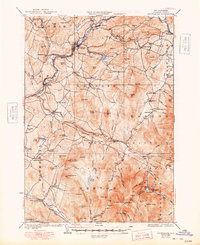
1932 Map of Moosilauke
USGS Topo · Published 1948About this map
Mt Moosilauke anchors the southeastern landscape of this White Mountains survey, where the high-altitude Tiptop House stands near the Appalachian Trail. The terrain transitions from the high peaks of the White Mountain National Forest to the river valleys of the Ammonoosuc River and Wild Ammonoosuc River. This 1930s era was defined by the presence of the Boston and Maine railroad, which connected the valley settlements of Lisbon, Bath, and East Haverhill. The map reveals a dense network of rural infrastructure, including numerous one-room schoolhouses like Ireland Sch and Nutter Sch, alongside industrial traces like Ore Hill. Landmarks such as the Black Mtn Fire Tower and the State Sanitarium (Rumney) underscore the varied use of this New Hampshire wilderness, from early conservation efforts to specialized public health facilities.
Find a feature on this map
129 named features on this map. Tap any name to fly to it.
Don’t see what you’re looking for? This feature index may not catch every label — zoom into the map to look around manually.
Map Details
Editions of this 1932 Moosilauke Map
5 editions found

Other maps of this area

1900 · Whitefield
USGS Topo · 1:62,500

1928 · Plymouth
USGS Topo · 1:62,500

1928 · Rumney
USGS Topo · 1:62,500

1929 · Moosilauke
USGS Topo · 1:62,500

1929 · Franconia
USGS Topo · 1:62,500

1931 · Mt. Cube
USGS Topo · 1:62,500

1931 · Littleton
USGS Topo · 1:62,500

1931 · Plymouth
USGS Topo · 1:62,500

1931 · Woodsville
USGS Topo · 1:48,000

1932 · Franconia
USGS Topo · 1:62,500