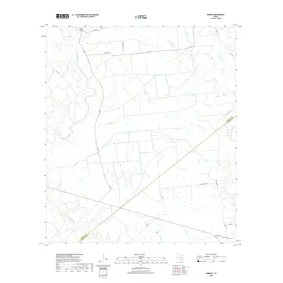
2019 Map of Morales
USGS Topo · Published 2019About this map
Morales serves as a central point of interest in this rural Jackson County landscape, where the Lavaca County and Jackson County line bisects a network of cattle ranches and creek drainages. The area is defined by its significant watercourses, including the Lavaca River winding through the western portion and the Navidad River touching the eastern edge. Settlement patterns are primarily agricultural and decentralized, with large holdings like the Deer Park Ranch and numerous county roads providing access to the interior. Local history is anchored by the Partridge Cem and the Wallace Bridge crossing Coal Cr, reflecting a long-standing ranching economy. The topography is etched by numerous seasonal branches such as Water Hole Br, Hall Br, and Hardys Sandy Cr, which drain the coastal plains toward the Gulf.
Find a feature on this map
28 named features on this map. Tap any name to fly to it.
Don’t see what you’re looking for? This feature index may not catch every label — zoom into the map to look around manually.
Map Details
Editions of this 2019 Morales Map
This is the sole edition of this map. No revisions or reprints were ever made.
Other maps of this area

1953 · Seguin
USGS Topo · 1:250,000

1958 · Seguin
USGS Topo · 1:250,000

1962 · Hallettsville SE
USGS Topo · 1:24,000

1963 · Mount Olive
USGS Topo · 1:24,000

1964 · Cordele
USGS Topo · 1:24,000

1964 · Morales
USGS Topo · 1:24,000

1964 · Speaks
USGS Topo · 1:24,000
1964 · Navidad
USGS Topo · 1:24,000

1964 · Ezzell
USGS Topo · 1:24,000

1965 · Hope
USGS Topo · 1:24,000