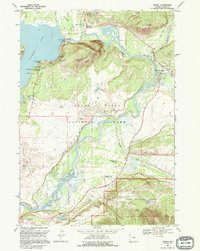
1968 Map of Moran
USGS Topo · Published 1995About this map
Snake River hydrology and early cattle ranching culture define this 1968 landscape within Grand Teton National Park. The map documents a critical period of park management, showing the infrastructure of the Jackson Lake Dam alongside legacy working landscapes like the Triangle X Ranch, Moose Head Ranch, and Wolff Ranch. The braiding of the river through Jackson Hole is captured in detail, from the iconic Oxbow Bend down to Deadmans Bar. This survey serves as a vital record for genealogists and local historians tracking the transition from frontier homesteads to federal preservation, featuring the Cunningham Cabin (Historic Site) and the original settlement of Moran near the confluence of the Buffalo Fork. It further details mid-century tourism facilities such as the Signal Mtn Lodge and various overlooks along the Teton Park Road.
Find a feature on this map
52 named features on this map. Tap any name to fly to it.
Don’t see what you’re looking for? This feature index may not catch every label — zoom into the map to look around manually.
Map Details
Editions of this 1968 Moran Map
2 editions found
Other maps of this area

1899 · Grand Teton
USGS Topo · 1:125,000

1901 · Grand Teton
USGS Topo · 1:125,000

1902 · Mt Leidy
USGS Topo · 1:125,000

1955 · Driggs
USGS Topo · 1:250,000

1958 · Driggs
USGS Topo · 1:250,000

1962 · Driggs
USGS Topo · 1:250,000

1965 · Davis Hill
USGS Topo · 1:24,000

1965 · Mount Leidy
USGS Topo · 1:24,000
1965 · Whetstone Mountain
USGS Topo · 1:24,000

1968 · Moose
USGS Topo · 1:24,000