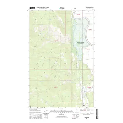
2017 Map of Moravia
USGS Topo · Published 2017About this map
Moravia and the small settlement of Burns anchor the low-lying eastern portion of this Boundary County terrain, where the Kootenai River makes a sweeping bend northward. The transition from the valley floor to the high timber is abrupt, with the Kootenai National Wildlife Refuge protecting the river bottom while the Kaniksu National Forest encompasses the high ridges to the west. Genealogical interest centers on the Moravia Cem and the network of rural roads such as Moravia Rd and Hickory Rd that connect early farmsteads.
Find a feature on this map
44 named features on this map. Tap any name to fly to it.
Don’t see what you’re looking for? This feature index may not catch every label — zoom into the map to look around manually.
Map Details
Editions of this 2017 Moravia Map
This is the sole edition of this map. No revisions or reprints were ever made.
Other maps of this area

1911 · Priest Lake
USGS Topo · 1:250,000

1913 · Priest Lake
USGS Topo · 1:250,000

1958 · Sandpoint
USGS Topo · 1:250,000

1963 · Sandpoint
USGS Topo · 1:250,000

1965 · Farnham Peak
USGS Topo · 1:24,000

1965 · Twentymile Creek
USGS Topo · 1:24,000

1965 · Moravia
USGS Topo · 1:24,000

1965 · Ritz
USGS Topo · 1:24,000

1965 · Naples
USGS Topo · 1:24,000
1965 · Bonners Ferry
USGS Topo · 1:24,000