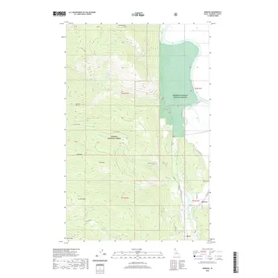
2020 Map of Moravia
USGS Topo · Published 2020About this map
The Kootenai River valley dominates the eastern edge of this region, where the Kootenai National Wildlife Refuge preserves a landscape of wetlands and river bends. Local history centers on the settlement of Moravia, located near the Moravia Cem and the junction of Moravia Rd. To the west, the terrain rises sharply into the Kaniksu National Forest, a series of high ridges and peaks including Snow Peak and Caribou Ridge. This transition from the river bottom to the high country is marked by steep drainages like Snow Cr, which features Snow Creek Falls. A network of forest roads and trails, such as the Ole Humpback Trail and Deep Creek Trail, provides access to the backcountry, while the Kootenai River Dike Trail follows the river's edge, illustrating the area's dual nature as a managed wildland and a rural residential corridor.
Find a feature on this map
45 named features on this map. Tap any name to fly to it.
Don’t see what you’re looking for? This feature index may not catch every label — zoom into the map to look around manually.
Map Details
Editions of this 2020 Moravia Map
This is the sole edition of this map. No revisions or reprints were ever made.
Other maps of this area

1911 · Priest Lake
USGS Topo · 1:250,000

1913 · Priest Lake
USGS Topo · 1:250,000

1958 · Sandpoint
USGS Topo · 1:250,000

1963 · Sandpoint
USGS Topo · 1:250,000

1965 · Farnham Peak
USGS Topo · 1:24,000

1965 · Twentymile Creek
USGS Topo · 1:24,000

1965 · Moravia
USGS Topo · 1:24,000

1965 · Ritz
USGS Topo · 1:24,000

1965 · Naples
USGS Topo · 1:24,000
1965 · Bonners Ferry
USGS Topo · 1:24,000