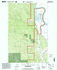
1996 Map of Moravia
USGS Topo · Published 1999About this map
Moravia and the surrounding timberlands of the Kaniksu National Forest define this 1990s survey of Idaho's northern panhandle. The Kootenai River snakes through the eastern landscape, supporting the Kootenai National Wildlife Refuge and a network of technical infrastructure including a pumping station and gaging station. The transition from the river valley to the steep high country is marked by landmarks like Snow Peak and the Myrtle Creek State Game Preserve.
Find a feature on this map
26 named features on this map. Tap any name to fly to it.
Don’t see what you’re looking for? This feature index may not catch every label — zoom into the map to look around manually.
Map Details
Editions of this 1996 Moravia Map
This is the sole edition of this map. No revisions or reprints were ever made.
Other maps of this area

1911 · Priest Lake
USGS Topo · 1:250,000

1913 · Priest Lake
USGS Topo · 1:250,000

1958 · Sandpoint
USGS Topo · 1:250,000

1963 · Sandpoint
USGS Topo · 1:250,000

1965 · Farnham Peak
USGS Topo · 1:24,000

1965 · Twentymile Creek
USGS Topo · 1:24,000

1965 · Moravia
USGS Topo · 1:24,000

1965 · Ritz
USGS Topo · 1:24,000

1965 · Naples
USGS Topo · 1:24,000
1965 · Bonners Ferry
USGS Topo · 1:24,000