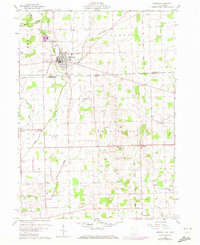
1960 Map of Morenci
USGS Topo · Published 1972About this map
The town of Morenci straddles the Michigan-Ohio border, serving as a focal point for this 1960s agricultural and transit landscape. The topography is defined by the winding course of Bean Creek and its tributaries, including Silver Creek and Iron Creek, which flow through the townships of Seneca, Chesterfield, and Gorham. Transportation infrastructure is prominent, with the Penn Central and Detroit Toledo and Ironton railroads intersecting the region. Cultural and community landmarks are scattered across the rural acreage, from the Morenci Landing Field and a Drive-in Theater to local gathering spots like Riverside Park. Genealogists will find significant value in the detailed plotting of several burial grounds, such as Oak Grove Cemetery, Rose Cem, and Butler Cem, alongside country congregations like East Chesterfield Ch.
Find a feature on this map
34 named features on this map. Tap any name to fly to it.
Don’t see what you’re looking for? This feature index may not catch every label — zoom into the map to look around manually.
Map Details
Editions of this 1960 Morenci Map
3 editions found
Other maps of this area

1911 · Wauseon
USGS Topo · 1:62,500

1913 · Wauseon
USGS Topo · 1:62,500

1913 · Alvordton
USGS Topo · 1:62,500

1943 · Wauseon
USGS Topo · 1:62,500

1944 · Alvordton
USGS Topo · 1:62,500

1953 · Fort Wayne
USGS Topo · 1:250,000

1956 · Fort Wayne
USGS Topo · 1:250,000

1959 · Archbold
USGS Topo · 1:24,000
1960 · Wauseon
USGS Topo · 1:24,000

1960 · Morenci
USGS Topo · 1:24,000