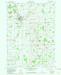
1960 Map of Morenci
USGS Topo · Published 1981About this map
Bean Creek serves as a central artery for this borderland landscape, winding southward past Morenci toward the Michigan Ohio state line. The area exhibits a dense network of rural infrastructure typical of the mid-20th century, where local life centered around points like Oak Grove Cemetery and the Riverside Park. The intersection of the Penn Central and the Detroit Toledo and Ironton railroads underscores the importance of rail transit for small agricultural hubs during this period.
Find a feature on this map
34 named features on this map. Tap any name to fly to it.
Don’t see what you’re looking for? This feature index may not catch every label — zoom into the map to look around manually.
Map Details
Editions of this 1960 Morenci Map
3 editions found
Other maps of this area

1911 · Wauseon
USGS Topo · 1:62,500

1913 · Wauseon
USGS Topo · 1:62,500

1913 · Alvordton
USGS Topo · 1:62,500

1943 · Wauseon
USGS Topo · 1:62,500

1944 · Alvordton
USGS Topo · 1:62,500

1953 · Fort Wayne
USGS Topo · 1:250,000

1956 · Fort Wayne
USGS Topo · 1:250,000

1959 · Archbold
USGS Topo · 1:24,000
1960 · Wauseon
USGS Topo · 1:24,000

1960 · Morenci
USGS Topo · 1:24,000