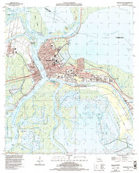
1994 Map of Morgan City
USGS Topo · Published 1998About this map
Morgan City and Berwick occupy a vital junction where the Atchafalaya River meets the Intracostal Waterway, forming a dense network of waterborne commerce and industrial activity. The landscape is defined by its engineering, featuring the Bayou Boeuf Lock, the Flat Lake Floodway, and numerous levees protecting the town from the surrounding basin. The eastern expansion of the city includes the settlements of Wyandotte, Siracusaville, and Greenwood, which developed along the Southern Pacific rail line. Beyond the urban centers, the map reveals an environment dominated by water and extraction, from the Lake Palourde Gas Field to the labyrinthine wetlands of Avoca Island and Bateman Island. The presence of the Landing Strip and Comm Tower installations alongside older landmarks like Bradley Cem illustrates the layered development of this maritime gateway.
Find a feature on this map
92 named features on this map. Tap any name to fly to it.
Don’t see what you’re looking for? This feature index may not catch every label — zoom into the map to look around manually.
Map Details
Editions of this 1994 Morgan City Map
This is the sole edition of this map. No revisions or reprints were ever made.
Other maps of this area

1935 · Morgan City
USGS Topo · 1:62,500

1941 · Belle Isle
USGS Topo · 1:62,500

1945 · New Orleans
USGS Topo · 1:250,000

1948 · Foster
USGS Topo · 1:62,500

1953 · Napoleonville
USGS Topo · 1:62,500

1954 · Morgan City
USGS Topo · 1:62,500

1954 · Belle Isle
USGS Topo · 1:62,500

1959 · Foster
USGS Topo · 1:62,500

1963 · New Orleans
USGS Topo · 1:250,000
1965 · Grassy Lake
USGS Topo · 1:24,000