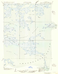
1954 Map of Morgan Harbor
USGS Topo · Published 1954About this map
Bayou La Loutre and the surrounding coastal marshlands of St. Bernard Parish are meticulously documented in this mid-century survey based on 1935 field examinations. The landscape is a complex labyrinth of waterways, punctuated by named points and islands such as Comfort Island and Rawhead. Significant maritime features like Morgan Harbor Pass and Treasure Bay indicate the essential role of water-based navigation in this tidal environment. The transition from the inland Skiff Lake and Whitelog Lake to the open Chandeleur Sound illustrates the precarious geography of the Louisiana coast before modern shoreline changes. Locations such as Deadman Pt on the Chandeleur Islands and the sheltered Twilight Harbor suggest a history of maritime activity and local place-naming by the fishermen and trappers who once worked these marshes.
Find a feature on this map
35 named features on this map. Tap any name to fly to it.
Don’t see what you’re looking for? This feature index may not catch every label — zoom into the map to look around manually.
Map Details
Editions of this 1954 Morgan Harbor Map
This is the sole edition of this map. No revisions or reprints were ever made.
Other maps of this area

1893 · La Fortuna
USGS Topo · 1:62,500

1893 · Chandeleur
USGS Topo · 1:62,500

1895 · Bodreau
USGS Topo · 1:62,500

1935 · Morgan Harbor
USGS Topo · 1:31,680

1935 · Lake Athanasio
USGS Topo · 1:31,680

1935 · Mitchell Keys
USGS Topo · 1:31,680

1946 · Oak Mound Bayou
USGS Topo · 1:31,680

1946 · Lake Eugenie
USGS Topo · 1:31,680
1947 · Lake Athanasio
USGS Topo · 1:31,680
1947 · Lake Eloi
USGS Topo · 1:31,680