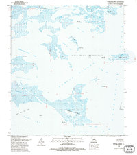
1994 Map of Morgan Harbor
USGS Topo · Published 1995About this map
Industrial infrastructure and maritime navigation define this coastal survey of St. Bernard Parish, dominated by expansive energy extraction zones like the Block 25 Oil and Gas Field and the Treasure Bay Gas Field. Multiple offshore platforms are precisely located across the shallow waters of Morgan Harbor and Eloi Bay, marking the active economic footprint of the Gulf at this time. The landscape is a labyrinth of salt marsh and tidal waterways, featuring intricate passages like Jules Cutoff, Treasure Bay Pass, and the prominent Bayou La Loutre. Geographic landmarks such as Dry Bread Island, Point Eliza, and Point Cahill provide essential orientation for navigation within Chandeleur Sound. This map serves as a vital record of the Louisiana coastline's specific shoreline configurations and industrial development before the significant erosional changes of the late 20th century.
Find a feature on this map
34 named features on this map. Tap any name to fly to it.
Don’t see what you’re looking for? This feature index may not catch every label — zoom into the map to look around manually.
Map Details
Editions of this 1994 Morgan Harbor Map
This is the sole edition of this map. No revisions or reprints were ever made.
Other maps of this area

1893 · La Fortuna
USGS Topo · 1:62,500

1893 · Chandeleur
USGS Topo · 1:62,500

1895 · Bodreau
USGS Topo · 1:62,500

1935 · Morgan Harbor
USGS Topo · 1:31,680

1935 · Lake Athanasio
USGS Topo · 1:31,680

1935 · Mitchell Keys
USGS Topo · 1:31,680

1946 · Oak Mound Bayou
USGS Topo · 1:31,680

1946 · Lake Eugenie
USGS Topo · 1:31,680
1947 · Lake Athanasio
USGS Topo · 1:31,680
1947 · Lake Eloi
USGS Topo · 1:31,680