
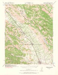
1939 Map of Morgan Hill
USGS Topo · Published 1957About this map
The Santa Clara Valley stretches through this 1939 survey, capturing a landscape of agriculture and burgeoning settlements before the post-war suburban shift. The Southern Pacific rail line and U.S. 101 serve as the primary north-south spine, connecting towns like Morgan Hill and Gilroy with smaller stops such as Madrone and Coyote. In the eastern hills, the newly constructed Coyote Reservoir dominates the drainage of Coyote Creek, while the western edge is defined by the steep slopes of the Santa Cruz Mountains and the landmark peak of Mt Madonna. Numerous rural schoolhouses, including Encinal School and Machado School, are scattered across the valley floor, documenting the decentralized community structure of the era. The presence of Old Gilroy near the map's southern edge highlights the historical shift in the region's urban center over time.
Find a feature on this map
89 named features on this map. Tap any name to fly to it.
Don’t see what you’re looking for? This feature index may not catch every label — zoom into the map to look around manually.
Map Details
Editions of this 1939 Morgan Hill Map
2 editions found
Other maps of this area

1889 · San Jose
USGS Topo · 1:62,500

1897 · San Jose
USGS Topo · 1:62,500

1897 · Mt. Hamilton
USGS Topo · 1:62,500

1899 · San Jose
USGS Topo · 1:62,500

1912 · Capitola
USGS Topo · 1:62,500

1914 · Capitola
USGS Topo · 1:62,500

1915 · San Juan Bautista
USGS Topo · 1:48,000

1916 · New Almaden
USGS Topo · 1:48,000

1917 · Morgan Hill
USGS Topo · 1:62,500

1917 · San Juan Bautista
USGS Topo · 1:62,500