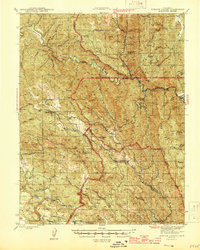
1944 Map of Morgan Valley
USGS Topo · Published 1944About this map
Mining operations and isolated cattle ranches define the character of this 1940s landscape where Lake, Napa, and Yolo counties converge. The rugged interior is dominated by the Blue Ridge and Rocky Ridge, with the settlement of Knoxville serving as a central point for the surrounding industrial activity. Extensive cinnabar or mercury mining is evident through the presence of the Reid Mine, Harrison Mine, Manhattan Mine, and the Red Elephant Mine, reflecting the region's importance to wartime mineral production.
Find a feature on this map
60 named features on this map. Tap any name to fly to it.
Don’t see what you’re looking for? This feature index may not catch every label — zoom into the map to look around manually.
Map Details
Editions of this 1944 Morgan Valley Map
2 editions found

Other maps of this area

1907 · Colusa
USGS Topo · 1:62,500

1918 · Spring Valley
USGS Topo · 1:31,680

1920 · Venado
USGS Topo · 1:62,500

1924 · Bartlett Springs
USGS Topo · 1:62,500

1924 · Capay
USGS Topo · 1:62,500

1927 · Calistoga
USGS Topo · 1:62,500

1942 · Colusa
USGS Topo · 1:62,500

1942 · Bartlett Springs
USGS Topo · 1:62,500

1942 · St. Helena
USGS Topo · 1:62,500

1943 · Morgan Valley
USGS Topo · 1:62,500