
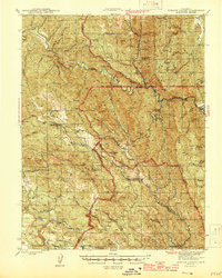
1944 Map of Morgan Valley
USGS Topo · Published 1944About this map
Reid Mine, Harrison Mine, and the Manhattan Mine anchor an active mining landscape along the borders of Lake, Colusa, and Napa counties during the early 1940s. Centered on the settlement of Knoxville, this area shows a distinct pattern of isolated ranching and resource extraction. The presence of the Morgan Valley Sch near Grizzly Pk indicates a established community presence in the valley, while named holdings like Hennesey Ranch and Ink Ranch reflect the private land use of the era. The terrain is defined by the significant drainage of Cache Creek and Putah Creek, with many smaller seasonal tributaries such as Butcherknife Creek and Jerusalem Creek carving through the high ridges. These water sources and family-named landmarks provide a detailed look at the rural northern California interior before mid-century development altered many such remote outposts.
Find a feature on this map
81 named features on this map. Tap any name to fly to it.
Don’t see what you’re looking for? This feature index may not catch every label — zoom into the map to look around manually.
Map Details
Editions of this 1944 Morgan Valley Map
2 editions found
Other maps of this area

1907 · Colusa
USGS Topo · 1:62,500

1918 · Spring Valley
USGS Topo · 1:31,680

1920 · Venado
USGS Topo · 1:62,500

1924 · Bartlett Springs
USGS Topo · 1:62,500

1924 · Capay
USGS Topo · 1:62,500

1927 · Calistoga
USGS Topo · 1:62,500

1942 · Colusa
USGS Topo · 1:62,500

1942 · Bartlett Springs
USGS Topo · 1:62,500

1942 · St. Helena
USGS Topo · 1:62,500

1943 · Morgan Valley
USGS Topo · 1:62,500