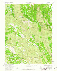
1958 Map of Morgan Valley
USGS Topo · Published 1962About this map
Cache Creek winds through this 1958 survey, carving a path between the Swanson Range and Brophy Ridge. The terrain is defined by a series of parallel northwest-trending ridges, including the Blue Ridge and Cortina Ridge, which create isolated pockets of activity like Wilson Valley and Jericho Valley. The industrial character of the era is evident through numerous mining operations scattered across the slopes, such as the Reid Mine, Royal Mine, and the Manhattan Mine located near the Knoxville area. Notable family holdings and early settlements are marked by the Hennesey Ranch, Ink Ranch, and Kennedy Flats. In the southeast, the rugged topography drops toward Zim Zim Falls and Eticuera Creek, while the Rumsey Rancheria sits near the eastern boundary. This document captures the complex intersection of Lake, Napa, Colusa, and Yolo counties before modern development altered these traditional ranching and mining landscapes.
Find a feature on this map
127 named features on this map. Tap any name to fly to it.
Don’t see what you’re looking for? This feature index may not catch every label — zoom into the map to look around manually.
Map Details
Editions of this 1958 Morgan Valley Map
2 editions found
Other maps of this area

1907 · Colusa
USGS Topo · 1:62,500

1918 · Spring Valley
USGS Topo · 1:31,680

1920 · Venado
USGS Topo · 1:62,500

1924 · Bartlett Springs
USGS Topo · 1:62,500

1924 · Capay
USGS Topo · 1:62,500

1927 · Calistoga
USGS Topo · 1:62,500

1942 · Colusa
USGS Topo · 1:62,500

1942 · Bartlett Springs
USGS Topo · 1:62,500

1942 · St. Helena
USGS Topo · 1:62,500

1943 · Morgan Valley
USGS Topo · 1:62,500