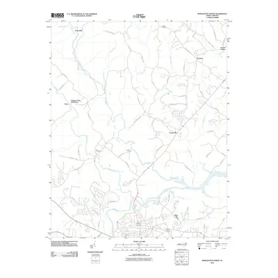
2010 Map of Morganton North
USGS Topo · Published 2010About this map
The Catawba River and the meandering Johns River define this North Carolina landscape just north of the regional hub of Morganton. During the first decade of the 21st century, the map reveals a transition from traditional rural settlements like Hartland and Chesterfield toward more formal residential developments, including the Piedmont Park Subdivision. Smaller, curiously named locales such as Worry and Perkinsville anchor the western reaches, while the terrain north of the river confluence is crisscrossed by family-named routes like Pax Hill Rd and Jim McCall Rd. Genealogists will find several notable burial sites preserved in this survey, including the Houck Cemetery in the north and the Bost Cemetery and Erwin Cemetery situated near the broad bend where the Warrior Fork joins the larger river system.
Find a feature on this map
64 named features on this map. Tap any name to fly to it.
Don’t see what you’re looking for? This feature index may not catch every label — zoom into the map to look around manually.
Map Details
Editions of this 2010 Morganton North Map
This is the sole edition of this map. No revisions or reprints were ever made.
Other maps of this area

1905 · Morganton
USGS Topo · 1:125,000

1953 · Charlotte
USGS Topo · 1:250,000

1954 · Charlotte
USGS Topo · 1:250,000

1956 · Valdese
USGS Topo · 1:24,000

1956 · Oak Hill
USGS Topo · 1:24,000

1956 · Collettsville
USGS Topo · 1:24,000

1956 · Morganton North
USGS Topo · 1:24,000

1956 · Morganton South
USGS Topo · 1:24,000

1956 · Lenoir
USGS Topo · 1:24,000
1956 · Chestnut Mtn.
USGS Topo · 1:24,000