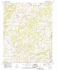
1989 Map of Morganton
USGS Topo · Published 1995About this map
The North Fork Cadron Creek winds through the heart of this Van Buren County landscape, defining the agricultural and settlement patterns of Greasy Valley. Small rural communities and church-centered hamlets like Morganton and Gravesville are connected by a network of backroads that navigate the area's prominent ridges, including Hunter Mountain and Pryor Mountain. A significant historical marker, the Indian Treaty Boundary, cuts across the terrain, reflecting the early political divisions of the region. Local genealogy is well-represented through numerous country churches such as Colony Ch and Mount Zion Ch, as well as the Hardin Cem. The landscape transitions from the high ground of Batesville Mtn in the south to the complex creek systems of Linn Creek and Little Creek in the north, showing a late 20th-century snapshot of traditional Arkansas uplands.
Find a feature on this map
36 named features on this map. Tap any name to fly to it.
Don’t see what you’re looking for? This feature index may not catch every label — zoom into the map to look around manually.
Map Details
Editions of this 1989 Morganton Map
This is the sole edition of this map. No revisions or reprints were ever made.
Other maps of this area

1892 · Mountain View
USGS Topo · 1:125,000

1894 · Mountain View
USGS Topo · 1:125,000

1956 · Russellville
USGS Topo · 1:250,000

1961 · Bee Branch
USGS Topo · 1:62,500

1961 · Bee Branch
USGS Topo · 1:24,000

1961 · Morganton
USGS Topo · 1:24,000

1961 · Damascus
USGS Topo · 1:24,000

1961 · Guy
USGS Topo · 1:24,000

1963 · Quitman
USGS Topo · 1:24,000
1963 · Barney
USGS Topo · 1:24,000