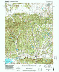
1998 Map of Morgantown
USGS Topo · Published 2002About this map
Yellowwood State Forest dominates this Central Indiana landscape, where the dense timber of Jackson and Washington townships meets the drainage of the Salt Creek and Beanblossom Creek systems. The map illustrates a late 20th-century view of a region defined by its conservation areas and small agricultural outposts like Morgantown and Fruitdale. A notable historical trace appears in the north, where an Old Railroad Grade follows the path of Indian Creek, marking the footprint of former transport lines that once linked these rural communities.
Find a feature on this map
42 named features on this map. Tap any name to fly to it.
Don’t see what you’re looking for? This feature index may not catch every label — zoom into the map to look around manually.
Map Details
Editions of this 1998 Morgantown Map
This is the sole edition of this map. No revisions or reprints were ever made.
Other maps of this area

1942 · Franklin
USGS Topo · 1:125,000

1946 · Belmont
USGS Topo · 1:24,000

1947 · Unionville
USGS Topo · 1:24,000

1947 · Nashville
USGS Topo · 1:24,000

1947 · Franklin
USGS Topo · 1:62,500

1948 · Trafalgar
USGS Topo · 1:24,000

1948 · Hindustan
USGS Topo · 1:24,000

1948 · Fruitdale
USGS Topo · 1:24,000

1948 · Morgantown
USGS Topo · 1:24,000

1949 · Nashville
USGS Topo · 1:24,000