1931 Map of Morgantown
USGS Topo · Published 1962About this map
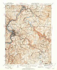
Morgantown serves as the industrial and academic anchor of this early 20th-century landscape, situated along the winding Monongahela River. The map captures the region's transition from heavy industry to a more settled rural pattern, showing the dense network of the Baltimore and Ohio Railroad connecting riverside settlements like Star City and Westover. To the east, Chestnut Ridge rises steeply, marked by remnants of the area's iron heritage at Clinton Furnace, Clay Furnace, and Laurel Iron Works. These landmarks, along with the Mont Chateau Quarry, reflect an economy deeply tied to the extraction and processing of local resources. Outside the urban center, the terrain is dotted with small communities and family-named schools such as McBee School and Gott School, illustrating the dispersed settlement patterns of Monongalia County before modern highway expansion.
Find a feature on this map
122 named features on this map. Tap any name to fly to it.
Don’t see what you’re looking for? This feature index may not catch every label — zoom into the map to look around manually.
Map Details
Editions of this 1931 Morgantown Map
This is the sole edition of this map. No revisions or reprints were ever made.
Other maps of this area

1886 · St. George
USGS Topo · 1:125,000

1891 · St. George
USGS Topo · 1:125,000

1900 · Uniontown
USGS Topo · 1:62,500

1900 · Masontown
USGS Topo · 1:62,500

1901 · Waynesburg
USGS Topo · 1:62,500

1902 · Fairmont
USGS Topo · 1:62,500

1902 · Morgantown
USGS Topo · 1:62,500

1903 · Masontown
USGS Topo · 1:62,500

1904 · Bruceton
USGS Topo · 1:62,500

1904 · Blacksville
USGS Topo · 1:62,500