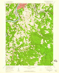
1957 Map of Morgantown South
USGS Topo · Published 1959About this map
The Monongahela River carves through the coal-rich hills south of Morgantown in the late 1950s, revealing an industrial landscape defined by river transport and deep-seated rural traditions. The Baltimore and Ohio tracks follow the river's bend, while the remnants of industry appear in the form of coke ovens near Richard and the namesake Clinton Furnace to the south. This era shows the expansion of residential life in South Hills contrasted with the deep hollows where family and community roots are anchored by institutions like Goshen Ch and Nicholson Chapel. The map documents a rugged transition from urban centers to the steep heights of Coal Lick Mountain, providing a clear look at the network of schools and churches, such as Vandevort Sch and Fairview Ch, that served these Monongalia County communities before modern development altered the rural corridors.
Find a feature on this map
89 named features on this map. Tap any name to fly to it.
Don’t see what you’re looking for? This feature index may not catch every label — zoom into the map to look around manually.
Map Details
Editions of this 1957 Morgantown South Map
Other maps of this area

1886 · St. George
USGS Topo · 1:125,000

1891 · St. George
USGS Topo · 1:125,000

1902 · Fairmont
USGS Topo · 1:62,500

1902 · Morgantown
USGS Topo · 1:62,500

1904 · Blacksville
USGS Topo · 1:62,500

1907 · Thornton
USGS Topo · 1:62,500

1923 · Blacksville
USGS Topo · 1:62,500

1923 · Fairmont
USGS Topo · 1:62,500

1925 · Blacksville
USGS Topo · 1:62,500

1925 · Morgantown
USGS Topo · 1:62,500