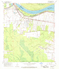
1968 Map of Morganza
USGS Topo · Published 1970About this map
The Morganza Floodway and its engineering controls dominate this landscape along the Mississippi River in the late 1960s. The town of Morganza sits at the intersection of the river's massive levee system and the Texas and Pacific railroad, serving as a gateway to the flood control infrastructure designed to protect the lower Atchafalaya Basin. Significant local history is preserved through the naming of Stonewall Plantation and smaller communities like Brownview, Dawson Switch, and Labarre. Beyond the levees, the terrain transitions into a complex network of waterways, including Bayou Portage and Bayou Buckhorn, where the land is carved into narrow drainage lots. Cultural markers are dense near the settlements, with multiple rural churches such as Bright Morning Star Ch and the Mt Airy Ch Cem providing specific touchpoints for genealogical research in this riverine corner of Pointe Coupee Parish.
Find a feature on this map
27 named features on this map. Tap any name to fly to it.
Don’t see what you’re looking for? This feature index may not catch every label — zoom into the map to look around manually.
Map Details
Editions of this 1968 Morganza Map
3 editions found
Other maps of this area

1906 · Bayou Sara
USGS Topo · 1:125,000

1939 · St. Francisville
USGS Topo · 1:62,500

1939 · Fordoche
USGS Topo · 1:62,500

1941 · Batchelor
USGS Topo · 1:62,500

1953 · New Roads
USGS Topo · 1:24,000

1954 · Fordoche
USGS Topo · 1:24,000

1954 · Erwinville
USGS Topo · 1:24,000

1954 · Baton Rouge
USGS Topo · 1:250,000

1955 · Fordoche
USGS Topo · 1:62,500

1955 · Batchelor
USGS Topo · 1:62,500