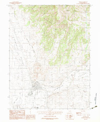
1983 Map of Moroni
USGS Topo · Published 1983About this map
Moroni sits at the intersection of irrigation and mountain geography in the Sanpete Valley, where the managed waters of the San Pitch River and Silver Creek meet the arid slopes of the Cedar Hills. The settlement's grid is defined by its agrarian utility, supported by the Moroni City Ditch and the nearby Mount Pleasant City Ditch. This 1983 provisional survey highlights a landscape of local infrastructure, from the Sewage Treatment Plant to a community Horse Race Track south of the town center. To the west, the Wales Reservoir provides a critical water source for the valley floor, while landmarks like Moroni Hill and Black Knob rise above the alluvial plains. This record preserves the town's footprint as it functioned in the late 20th century, balanced between industrial needs like the Gravel Pit and the natural drainage of Spring Hollow.
Find a feature on this map
20 named features on this map. Tap any name to fly to it.
Don’t see what you’re looking for? This feature index may not catch every label — zoom into the map to look around manually.
Map Details
Editions of this 1983 Moroni Map
2 editions found
Other maps of this area

1885 · Manti
USGS Topo · 1:250,000

1895 · Manti
USGS Topo · 1:250,000

1951 · Moroni
USGS Topo · 1:62,500

1956 · Price
USGS Topo · 1:250,000

1960 · Price
USGS Topo · 1:250,000

1962 · Price
USGS Topo · 1:250,000

1965 · Wales
USGS Topo · 1:24,000

1966 · Spring City
USGS Topo · 1:24,000

1966 · Chester
USGS Topo · 1:24,000
1967 · Mount Pleasant
USGS Topo · 1:24,000