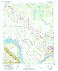
1961 Map of Morrilton West
USGS Topo · Published 1979About this map
The Arkansas River carves a significant sweep through the southern portion of this landscape, its course dictated by the looming presence of Petit Jean Mountain and the high vantage of Stouts Point. This 1961 survey, updated in the late 1970s, captures the transportation and infrastructure essential to the region, from the Missouri Pacific railroad corridor to Lock and Dam No 9. The county seat of Morrilton shows its late-century expansion near the junction of several townships including Welborn and Bentley.
Find a feature on this map
38 named features on this map. Tap any name to fly to it.
Don’t see what you’re looking for? This feature index may not catch every label — zoom into the map to look around manually.
Map Details
Editions of this 1961 Morrilton West Map
3 editions found
Other maps of this area

1889 · Morrilton No. 3
USGS Topo · 1:62,500

1892 · Morrillton
USGS Topo · 1:125,000

1894 · Morrillton
USGS Topo · 1:125,000

1956 · Russellville
USGS Topo · 1:250,000

1961 · Perryville
USGS Topo · 1:24,000

1961 · Morrilton East
USGS Topo · 1:24,000

1961 · Morrilton West
USGS Topo · 1:24,000

1961 · Houston
USGS Topo · 1:24,000

1961 · Adona
USGS Topo · 1:24,000

1961 · Atkins
USGS Topo · 1:24,000