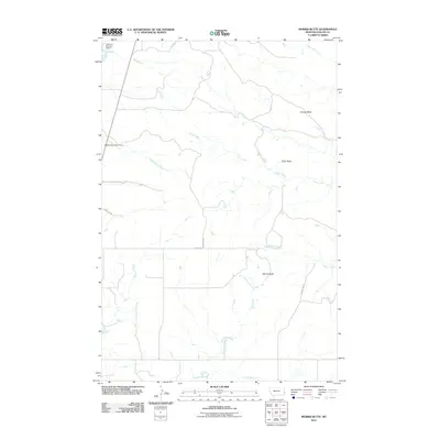
2011 Map of Morris Butte
USGS Topo · Published 2011About this map
Morris Butte stands as a prominent landmark in this segment of eastern Montana, where the high plains are carved by a network of intermittent drainage systems. The landscape is defined by its topographic reliefs, such as Grassy Butte and Cedar Butte, which rise above the surrounding prairie. Human intervention in this arid environment is evident through water management features like Mildred Number 1 Dam and Halmans Number 3 Dam, essential for livestock and local agriculture. The drainage patterns of Johny Creek, Sandstone Creek, and Cottonwood Creek dictate the local geography, while a sparse grid of rural routes, including County Rd 607 and Griffith Ln, provides access across the Fallon County terrain. This survey reflects a modern era of land use where large-scale ranching and watershed control define the rural character of the region.
Find a feature on this map
14 named features on this map. Tap any name to fly to it.
Don’t see what you’re looking for? This feature index may not catch every label — zoom into the map to look around manually.
Map Details
Editions of this 2011 Morris Butte Map
This is the sole edition of this map. No revisions or reprints were ever made.
Other maps of this area

1953 · Miles City
USGS Topo · 1:250,000

1957 · Miles City
USGS Topo · 1:250,000

1958 · Miles City
USGS Topo · 1:250,000

1981 · Baker
USGS Topo · 1:100,000

1981 · Baker NE
USGS Topo · 1:24,000

1981 · Buffalo Reservoir
USGS Topo · 1:24,000

1981 · Baker
USGS Topo · 1:24,000
1981 · Morris Butte
USGS Topo · 1:24,000
1981 · Badland Draw
USGS Topo · 1:24,000
1981 · Shell Butte
USGS Topo · 1:24,000