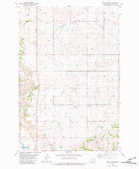
1981 Map of Shell Butte
USGS Topo · Published 1981About this map
Shell Butte and Big Hill anchor this high plains landscape in eastern Fallon County during the early 1980s. The terrain is defined by a dendritic network of drainages including Beaver Creek and Spring Creek, which reveal a sparsely populated ranching environment where water sources like numerous unnamed springs were critical to local land use. The small settlement of Schweigert sits in the southern portion of the map, marked by a nearby Radio Tower and Gravel Pit. Evidence of resource exploration is visible through several labeled wells and a Drill Hole scattered across the quadrangle, reflecting the region's energy and mineral interests. This survey captures the rural infrastructure of the Montana plains, from fence lines to remote tracks, before later development or changes in land management altered the footprint of these isolated outposts.
Find a feature on this map
13 named features on this map. Tap any name to fly to it.
Don’t see what you’re looking for? This feature index may not catch every label — zoom into the map to look around manually.
Map Details
Editions of this 1981 Shell Butte Map
This is the sole edition of this map. No revisions or reprints were ever made.
Other maps of this area

1953 · Miles City
USGS Topo · 1:250,000

1957 · Miles City
USGS Topo · 1:250,000

1958 · Miles City
USGS Topo · 1:250,000

1981 · Baker
USGS Topo · 1:100,000

1981 · Baker NE
USGS Topo · 1:24,000
1981 · Morris Butte
USGS Topo · 1:24,000

1981 · Cap Rock
USGS Topo · 1:24,000
1981 · Badland Draw
USGS Topo · 1:24,000

1981 · Carlyle
USGS Topo · 1:24,000
1981 · Rush Hall Reservoir
USGS Topo · 1:24,000