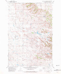
1981 Map of Rush Hall Reservoir
USGS Topo · Published 1981About this map
The energy economy of Fallon County defines this landscape in the early 1980s, marked by a dense network of extraction sites across the Monarch Oil Field and Cupton Field. Dozens of individual Oil Wells and Gas Wells are scattered throughout the territory, illustrating the intensive industrial development of the era. This resource extraction is integrated into a terrain drained by the Middle Fork Cabin Creek and Cabin Creek, which flow through a series of complex draws. Water management for the region's ranching or industrial needs is anchored by the Rush Hall Reservoir in the northeastern section, while various isolated Springs provide critical water points across the higher elevations of the R 58 E and R 59 E ranges.
Find a feature on this map
14 named features on this map. Tap any name to fly to it.
Don’t see what you’re looking for? This feature index may not catch every label — zoom into the map to look around manually.
Map Details
Editions of this 1981 Rush Hall Reservoir Map
This is the sole edition of this map. No revisions or reprints were ever made.
Other maps of this area

1953 · Miles City
USGS Topo · 1:250,000

1957 · Miles City
USGS Topo · 1:250,000

1958 · Miles City
USGS Topo · 1:250,000

1981 · Baker
USGS Topo · 1:100,000

1981 · Baker NE
USGS Topo · 1:24,000

1981 · Lawrence Creek East
USGS Topo · 1:24,000

1981 · Baker NW
USGS Topo · 1:24,000
1981 · Morris Butte
USGS Topo · 1:24,000

1981 · Cap Rock
USGS Topo · 1:24,000

1981 · Rocking Chair Butte
USGS Topo · 1:24,000