
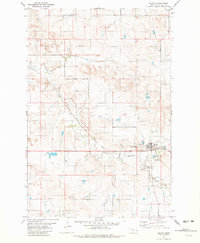
1981 Map of Lawrence Creek East
USGS Topo · Published 1981About this map
Cabin Creek Oil Field and the Monarch Field dominate this Eastern Montana landscape, illustrating the intensive energy development of the early 1980s. The terrain is defined by a dense network of extraction infrastructure, including numerous Oil Wells, a central Pumping Sta, and an extensive Pipeline system that cuts across the drainages. These industrial operations are situated among the intricate coulees and breaks formed by Cabin Creek, its Middle Fork, and Wills Creek. The map provides an exceptionally detailed look at the subsurface resource economy in Fallon County, where even minor landmarks like a Gravel Pit or a specific Drill Hole were documented to support the region's petroleum production and geological survey efforts.
Find a feature on this map
15 named features on this map. Tap any name to fly to it.
Don’t see what you’re looking for? This feature index may not catch every label — zoom into the map to look around manually.
Map Details
Editions of this 1981 Lawrence Creek East Map
This is the sole edition of this map. No revisions or reprints were ever made.
Other maps of this area

1953 · Miles City
USGS Topo · 1:250,000

1957 · Miles City
USGS Topo · 1:250,000

1958 · Miles City
USGS Topo · 1:250,000

1981 · Baker
USGS Topo · 1:100,000

1981 · Baker NE
USGS Topo · 1:24,000

1981 · Lawrence Creek West
USGS Topo · 1:24,000

1981 · Baker NW
USGS Topo · 1:24,000

1981 · Ayer Spring NE
USGS Topo · 1:24,000
1981 · Plevna
USGS Topo · 1:24,000

1981 · Cap Rock
USGS Topo · 1:24,000