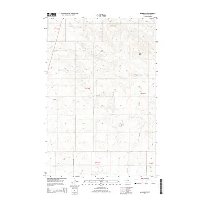
2014 Map of Morris Butte
USGS Topo · Published 2014About this map
Morris Butte rises as a prominent landmark in this segment of Fallon County, where the high plains of eastern Montana meet a complex network of intermittent drainages and ranch infrastructure. The landscape is defined by its series of erosional heights, including Grassy Butte and Cedar Butte, which overlook the winding paths of Johny Cr and Cannonball Cr. This terrain reflects a dual economy of traditional cattle ranching and mid-century energy development, evidenced by the presence of the Pennel Oil Field and specialized infrastructure like Shell Oil Rd. A dense grid of established tracks such as School House Rd and Johny Creek Trl suggests a long history of land division and rural community connectivity, even in this sparsely populated region. The map captures the quiet intersection of natural topography and industrial utility at the height of modern surveying.
Find a feature on this map
25 named features on this map. Tap any name to fly to it.
Don’t see what you’re looking for? This feature index may not catch every label — zoom into the map to look around manually.
Map Details
Editions of this 2014 Morris Butte Map
This is the sole edition of this map. No revisions or reprints were ever made.
Other maps of this area

1953 · Miles City
USGS Topo · 1:250,000

1957 · Miles City
USGS Topo · 1:250,000

1958 · Miles City
USGS Topo · 1:250,000

1981 · Baker
USGS Topo · 1:100,000

1981 · Baker NE
USGS Topo · 1:24,000

1981 · Buffalo Reservoir
USGS Topo · 1:24,000

1981 · Baker
USGS Topo · 1:24,000
1981 · Morris Butte
USGS Topo · 1:24,000
1981 · Badland Draw
USGS Topo · 1:24,000
1981 · Shell Butte
USGS Topo · 1:24,000