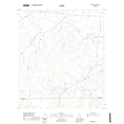
2019 Map of Morris Ranch
USGS Topo · Published 2019About this map
Morris Ranch sits as a primary landmark in this section of the Texas Hill Country, where the landscape is defined by the winding course of the Pedernales River. The terrain is deeply incised by numerous seasonal drainage systems, including White Oak Cr, Delaware Cr, and Wolf Cr, which create a series of ridges and valleys such as Kott Valley and Mitchke Valley. The settlement pattern is characterized by large ranching tracts connected by a network of rural roads, many bearing family names that reflect the local heritage, such as Alfred Petsch Rd and Henke Kott Rd.
Find a feature on this map
49 named features on this map. Tap any name to fly to it.
Don’t see what you’re looking for? This feature index may not catch every label — zoom into the map to look around manually.
Map Details
Editions of this 2019 Morris Ranch Map
This is the sole edition of this map. No revisions or reprints were ever made.
Other maps of this area

1894 · Fredericksburg
USGS Topo · 1:125,000

1894 · Kerrville
USGS Topo · 1:125,000

1954 · Llano
USGS Topo · 1:250,000

1955 · Llano
USGS Topo · 1:250,000

1956 · Llano
USGS Topo · 1:250,000

1964 · Oak Crest Park
USGS Topo · 1:24,000

1964 · Morris Ranch
USGS Topo · 1:24,000

1964 · Nott Branch
USGS Topo · 1:24,000
1964 · Cypress Creek
USGS Topo · 1:24,000
1964 · Kerrville
USGS Topo · 1:24,000