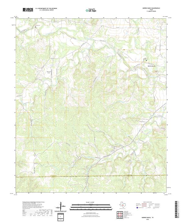
2022 Map of Morris Ranch
USGS Topo · Published 2022About this map
The Pedernales River meanders across the northern portion of this landscape, carving through a region defined by family ranching legacies and deep valleys. The settlement of Morris Ranch serves as a local anchor near the river, situated among the undulating terrain of Mitchke Valley and Kott Valley. Local history is preserved at the Hill Crest Cem and Tivydale Cem, while the White Oak Airport indicates modern accessibility in this rural expanse. A complex network of ranch roads, such as Coonrod-Grona Rd and Alfred Henke Rd, traces the ridges and drainages of Delaware Cr and Trough Spring Cr. This survey illustrates the enduring patterns of Gillespie County land use, where named springs like Trough Spring remain vital landmarks for local navigation and water management.
Find a feature on this map
52 named features on this map. Tap any name to fly to it.
Don’t see what you’re looking for? This feature index may not catch every label — zoom into the map to look around manually.
Map Details
Editions of this 2022 Morris Ranch Map
This is the sole edition of this map. No revisions or reprints were ever made.
Other maps of this area

1894 · Fredericksburg
USGS Topo · 1:125,000

1894 · Kerrville
USGS Topo · 1:125,000

1954 · Llano
USGS Topo · 1:250,000

1955 · Llano
USGS Topo · 1:250,000

1956 · Llano
USGS Topo · 1:250,000

1964 · Oak Crest Park
USGS Topo · 1:24,000

1964 · Morris Ranch
USGS Topo · 1:24,000

1964 · Nott Branch
USGS Topo · 1:24,000
1964 · Cypress Creek
USGS Topo · 1:24,000
1964 · Kerrville
USGS Topo · 1:24,000