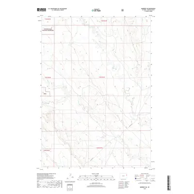
2018 Map of Morrisey NE
USGS Topo · Published 2018About this map
Thunder Basin National Grassland encompasses a significant portion of this Weston County terrain, where the high plains are defined by an intricate network of intermittent drainages. The landscape is characterized by the branching paths of Mush Cr, Beaver Cr, and Oil Cr, which cut through the open rangeland. The section lines of the Public Land Survey System divide the area into a regular grid, with Morrissey Rd serving as a primary corridor for movement through the territory. This 2018 survey illustrates the modern management of these public lands, noting specific sub-drainages like S Beaver Cr and Rough Cr that dictate the natural flow and grazing potential of the region. The map highlights the intersection of public conservation and the rural transportation network within the Tbng.
Find a feature on this map
14 named features on this map. Tap any name to fly to it.
Don’t see what you’re looking for? This feature index may not catch every label — zoom into the map to look around manually.
Map Details
Editions of this 2018 Morrisey NE Map
This is the sole edition of this map. No revisions or reprints were ever made.
Other maps of this area

1899 · Newcastle
USGS Topo · 1:125,000

1901 · Newcastle
USGS Topo · 1:125,000

1951 · Owens
USGS Topo · 1:24,000

1951 · Dewey SW
USGS Topo · 1:24,000

1951 · Newcastle
USGS Topo · 1:24,000

1951 · Morrisey NE
USGS Topo · 1:24,000

1951 · Osage SE
USGS Topo · 1:24,000

1955 · Newcastle
USGS Topo · 1:250,000

1958 · Newcastle
USGS Topo · 1:250,000
1958 · Newcastle
USGS Topo · 1:62,500