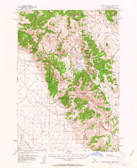
1956 Map of Morrison Lake
USGS Topo · Published 1963About this map
The Continental Divide serves as the spine of this mid-century survey, marking the high-altitude boundary between Beaverhead County and Lemhi County along the Idaho-Montana border. The landscape is defined by the intersection of the Salmon National Forest and Beaverhead National Forest, where the terrain drops sharply into the Lemhi Valley. Notable high points like Baldy Mtn tower over drainages such as Eighteenmile Creek and Medicine Lodge Creek. The presence of a remote Landing Strip and a network of Jeep Trails indicates the limited accessibility of these mountain ranges during the 1950s. Mining activity is subtly documented through labels for a Shaft and Prospect near the Montana side, while alpine features like Morrison Lake and the Deer Creek Reservoir reflect the critical water resources managed within these protected federal lands.
Find a feature on this map
48 named features on this map. Tap any name to fly to it.
Don’t see what you’re looking for? This feature index may not catch every label — zoom into the map to look around manually.
Map Details
Editions of this 1956 Morrison Lake Map
3 editions found
Other maps of this area

1955 · Dubois
USGS Topo · 1:250,000

1956 · Leadore
USGS Topo · 1:62,500

1956 · Morrison Lake
USGS Topo · 1:62,500

1956 · Nicholia
USGS Topo · 1:62,500

1957 · Gilmore
USGS Topo · 1:62,500

1957 · Scott Peak
USGS Topo · 1:62,500

1958 · Dubois
USGS Topo · 1:250,000

1965 · Deadman Pass
USGS Topo · 1:24,000

1965 · Graphite Mountain
USGS Topo · 1:24,000

1965 · Deer Canyon
USGS Topo · 1:24,000