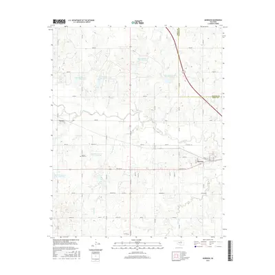
2016 Map of Morrison
USGS Topo · Published 2016About this map
The town of Morrison serves as the focal point of this Noble County landscape, situated at the junction of several county roads and highways. The surrounding terrain is defined by an extensive water management system, featuring numerous engineered basins such as Upper Black Bear Cr Site 2 Reservoir and Upper Black Bear Cr Site 5 Reservoir, which regulate the drainage of Black Bear Creek and its tributaries. To the west, the community of Sumner anchors the opposite side of the quadrangle near the banks of Mule Creek. Genealogists and local historians will find the Pleasant Valley Cemetery tucked away near Knob Hill, while the boundary between Noble and Pawnee counties cuts across the northeastern corner. The map reveals a highly structured rural grid, with family and local history potentially tied to named thoroughfares like Maverick, Lariat, and John Wayne.
Find a feature on this map
54 named features on this map. Tap any name to fly to it.
Don’t see what you’re looking for? This feature index may not catch every label — zoom into the map to look around manually.
Map Details
Editions of this 2016 Morrison Map
This is the sole edition of this map. No revisions or reprints were ever made.
Other maps of this area

1893 · Stillwater
USGS Topo · 1:62,500

1929 · Ripley
USGS Topo · 1:62,500

1930 · Pawnee
USGS Topo · 1:62,500

1932 · Ripley
USGS Topo · 1:62,500

1936 · Pawnee
USGS Topo · 1:62,500

1955 · Enid
USGS Topo · 1:250,000

1958 · Enid
USGS Topo · 1:250,000

1966 · Lake Carl Blackwell
USGS Topo · 1:24,000
1967 · Stillwater North
USGS Topo · 1:24,000

1972 · Morrison NE
USGS Topo · 1:24,000