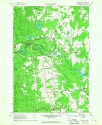
1966 Map of Morrisonville
USGS Topo · Published 1968About this map
The Saranac River winds through the heart of this Clinton County landscape, anchoring a series of industrial and residential nodes during the mid-1960s. Hydroelectric infrastructure is evident at the powerplant near Kent Falls, while the surrounding terrain is marked by numerous Gravel Pits, indicating the active extraction industry of the era. This survey captures the distinct community identities of Morrisonville, Cadyville, and the Irish Settlement, each connected by a network of historic thoroughfares like Old Military Road and the Military Turnpike. To the east, the Plattsburgh Municipal Airport and the County Fairgrounds represent the region's expanding mid-century civic infrastructure. Deep woodlots of the Clinton State Forest and the Salmon River valley provide a stark contrast to the developed corridors and scattered family cemeteries that define the local genealogy of the township.
Find a feature on this map
63 named features on this map. Tap any name to fly to it.
Don’t see what you’re looking for? This feature index may not catch every label — zoom into the map to look around manually.
Map Details
Editions of this 1966 Morrisonville Map
2 editions found
Other maps of this area

1894 · Plattsburg
USGS Topo · 1:62,500

1895 · Mooers
USGS Topo · 1:62,500

1895 · Rouse Point
USGS Topo · 1:62,500

1899 · Mooers
USGS Topo · 1:62,500

1906 · Plattsburg
USGS Topo · 1:62,500

1907 · Rouse Point
USGS Topo · 1:62,500

1913 · Dannemora
USGS Topo · 1:62,500

1939 · Rouses Point
USGS Topo · 1:62,500

1939 · Plattsburg
USGS Topo · 1:62,500

1941 · Plattsburg
USGS Topo · 1:62,500